Cryo-Bench
A benchmark for evaluating Geospatial Foundation Models on cryosphere applications.

A benchmark for evaluating Geospatial Foundation Models on cryosphere applications.
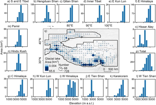
Global multi-sensor dataset for glacial lake mapping (S1 VV/VH, S2 bands, NDWI, DEM, slope).
Multisource Remote Sensing Dataset for training and evluating deep learning models for Debris-Covered Glacier Mapping (Global Supraglacial Debris Dataset GSDD)
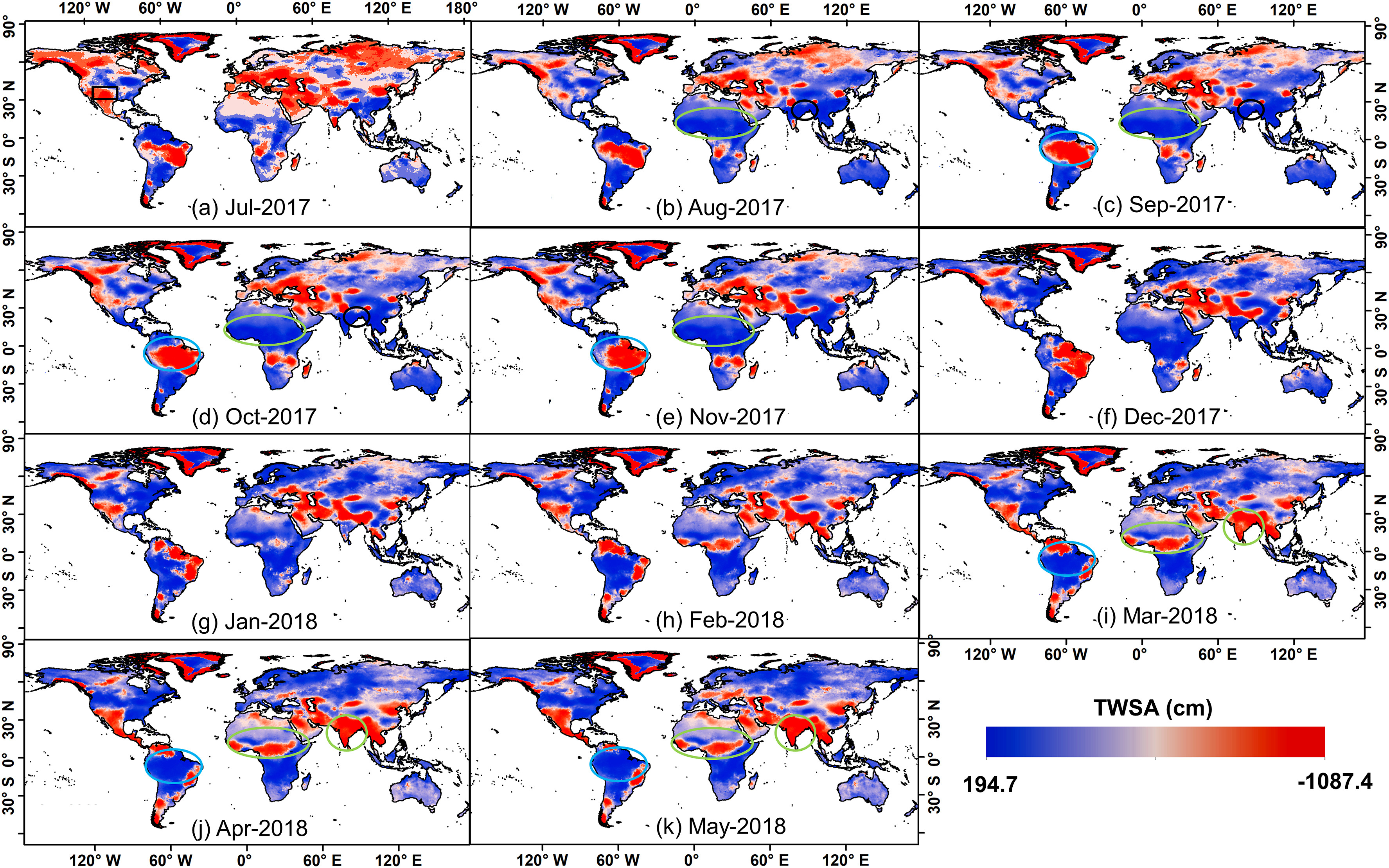
Gap-filled GRACE groundwater storage anomaly (GWSA) product.
Long-term groundwater storage anomaly trends for the Indus Basin.
Short description of portfolio item number 1
Short description of portfolio item number 2
Published in , 2010
Published in Geocarto International, 2018
Recommended citation: Kaushik, S.*, Dharpure, J.K., Joshi, P.K., Ramanathan, A.L., & Singh, T. (2018). Climate change drives glacier retreat in Bhaga basin located in Himachal Pradesh, India. Geocarto International.
Download Paper
Published in International Journal of Remote Sensing, 2019
Recommended citation: Kaushik, S.*, Joshi, P. K., & Singh, T. (2019). Development of glacier mapping in Indian Himalaya: a review of approaches. International Journal of Remote Sensing.
Download Paper
Published in Science of the Total Environment, 2020
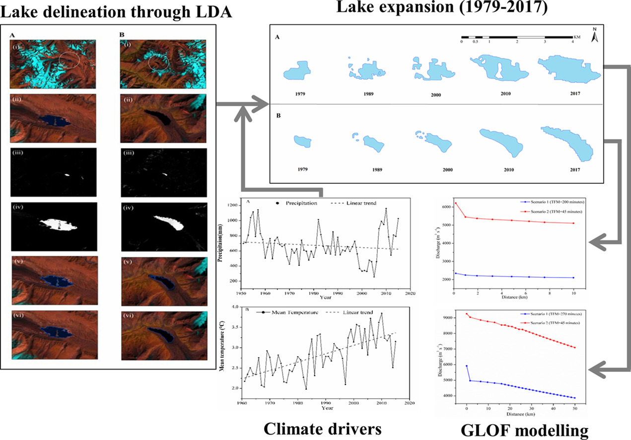
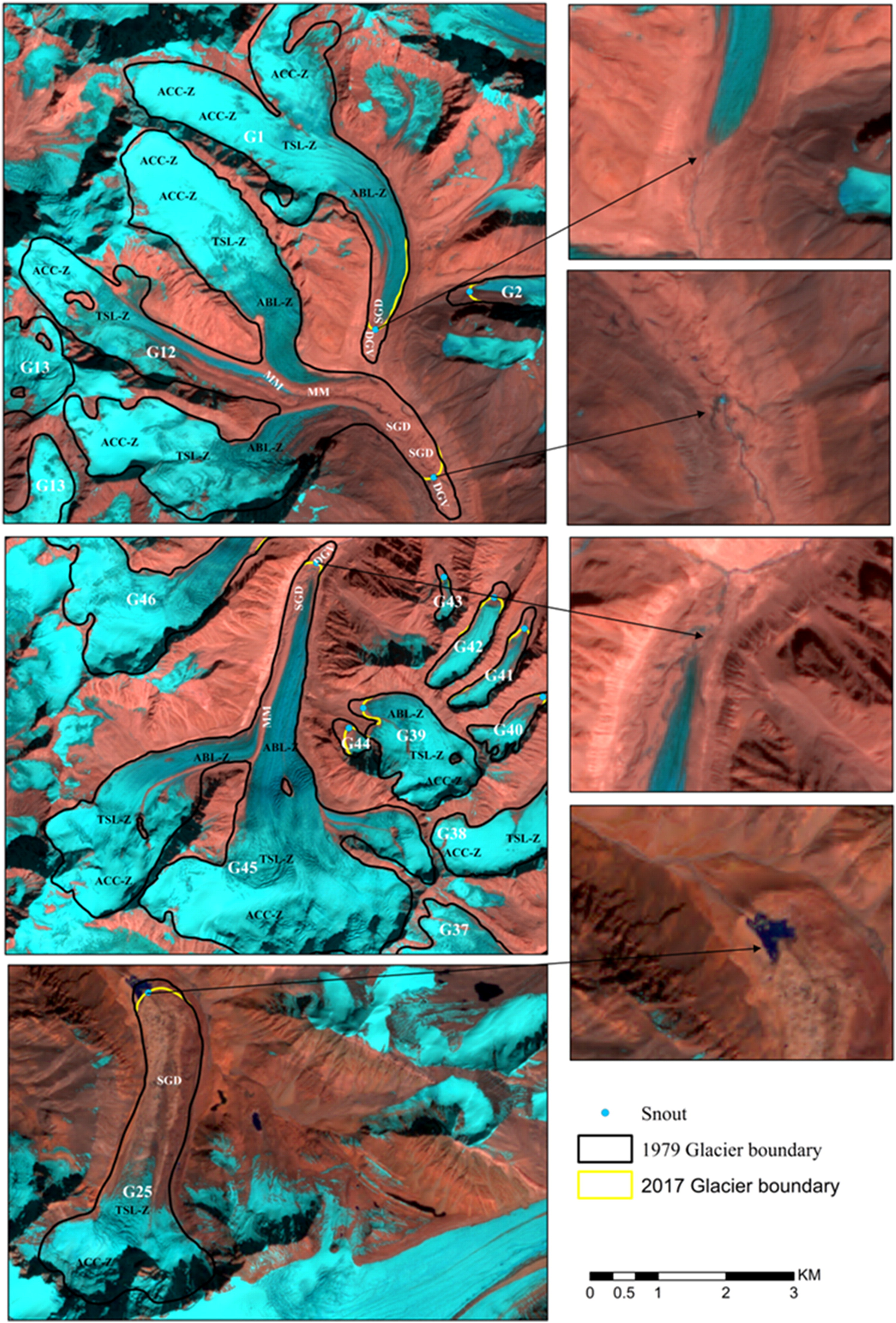
Recommended citation: Kaushik, S.*, Rafiq, M., Joshi, P. K., & Singh, T. (2020). Examining the Glacial Lake dynamics in a warming climate and GLOF modelling in parts of Chandra basin, Himachal Pradesh, India. Science of the Total Environment.
Download Paper
Published in Earth Surface Processes and Landforms, 2021
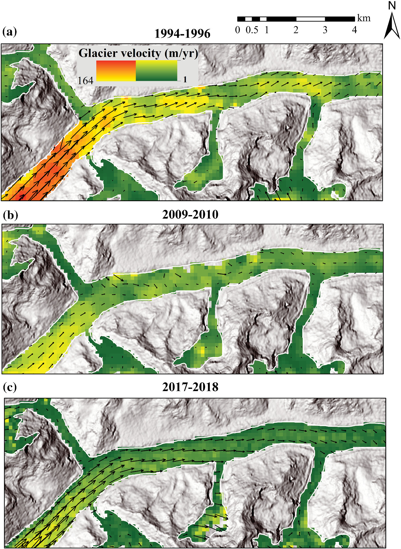
Recommended citation: Kaushik, S.*, Singh, T., Bhardwaj, A., & Joshi, P.K. (2021). Long-term spatiotemporal variability in the glacier surface velocity of Eastern Himalayan glaciers, India. Earth Surface Processes and Landforms.
Download Paper
Published in Remote Sensing, 2021
Recommended citation: Kaushik, S.*, Singh, T., Bhardwaj, A., Joshi, P.K., & Dietz, A.J. (2021). Automated delineation of supraglacial debris cover using deep learning and multisource remote sensing data. Remote Sensing.
Download Paper
Published in International Journal of Applied Earth Observation and Geoinformation, 2022
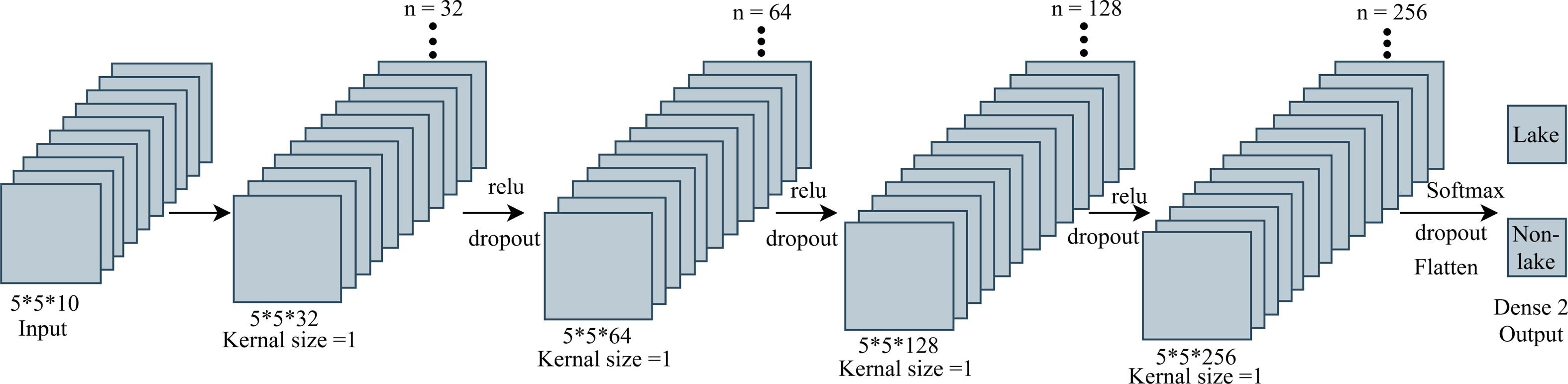
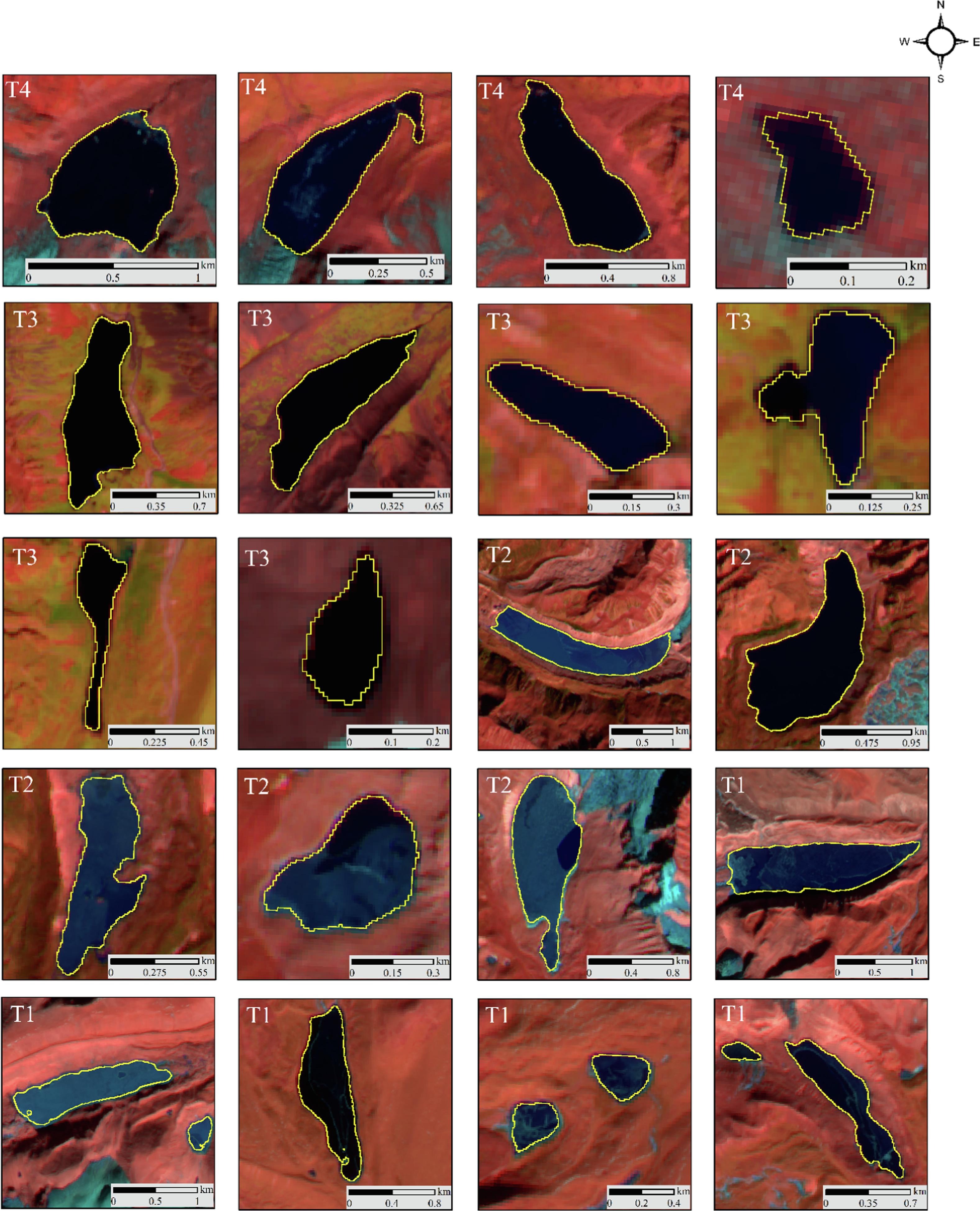
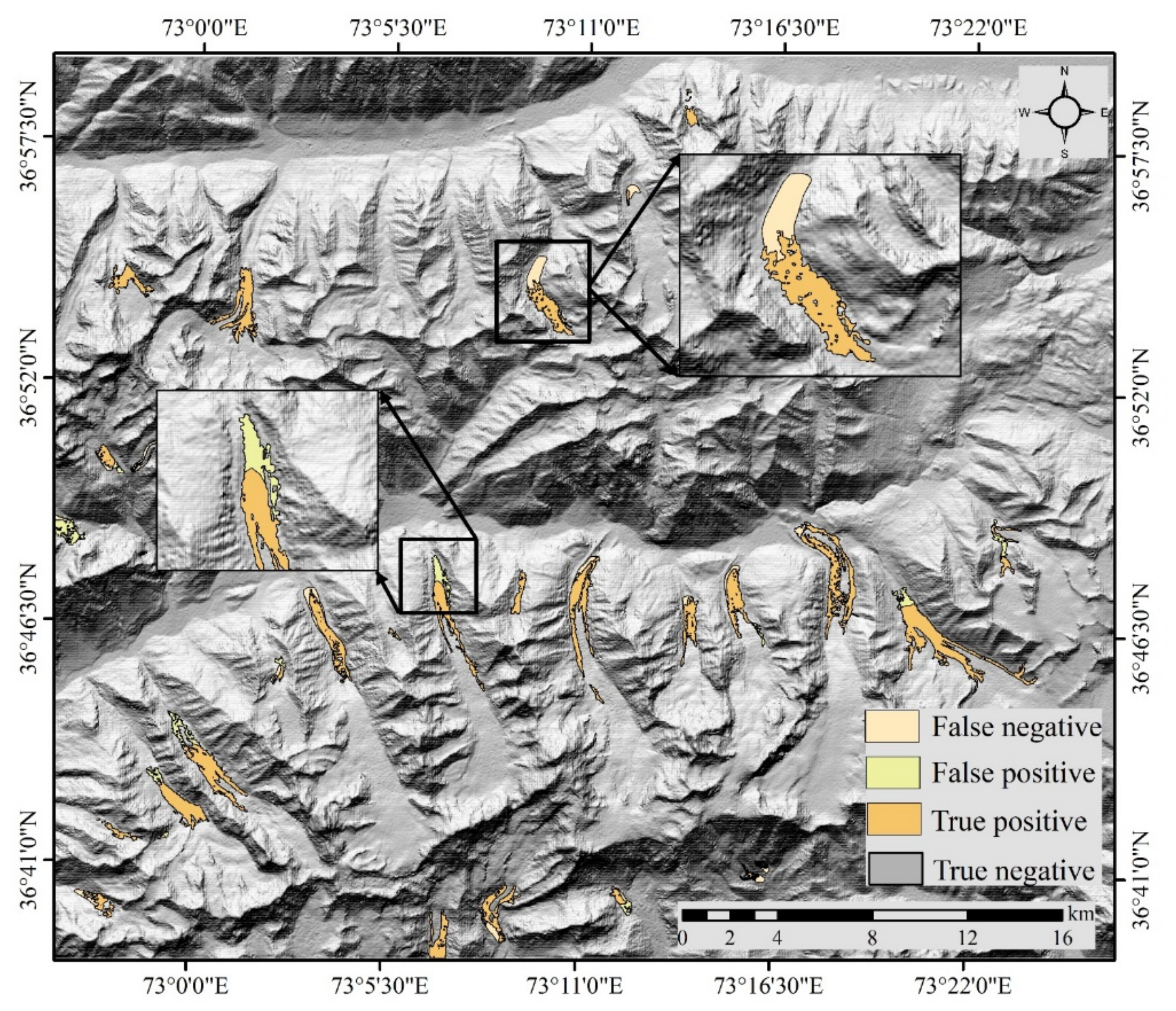
Recommended citation: Kaushik, S.*, Singh, T., Joshi, P.K., & Dietz, A.J. (2022). Automated mapping of glacial lakes using multisource remote sensing data and deep convolutional neural network. International Journal of Applied Earth Observation and Geoinformation.
Download Paper
Published in Geomatics Natural Hazards and Risk, 2023
Recommended citation: Pandey, A., Sarkar, S.M., Palni, S., Parashar, D., Singh, G., Kaushik, S., Chandra, N., Costache, R., Singh, P.A., Mishra, P.A., Almohamad, H., Al-Mutiry, M., & Ghassan, A.H. (2023). Landslide susceptibility assessment at the landscape level using multivariate analysis coupled with statistical algorithms: An insight from India’s Kailash Sacred Landscape, Western Himalaya. Geomatics Natural Hazards and Risk.
Download Paper
Published in Remote Sensing Applications: Society and Environment, 2024
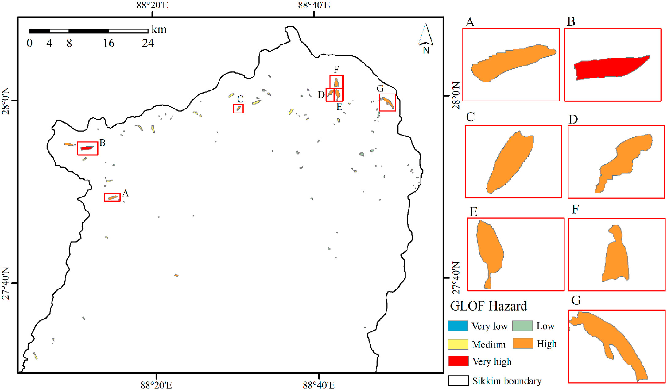
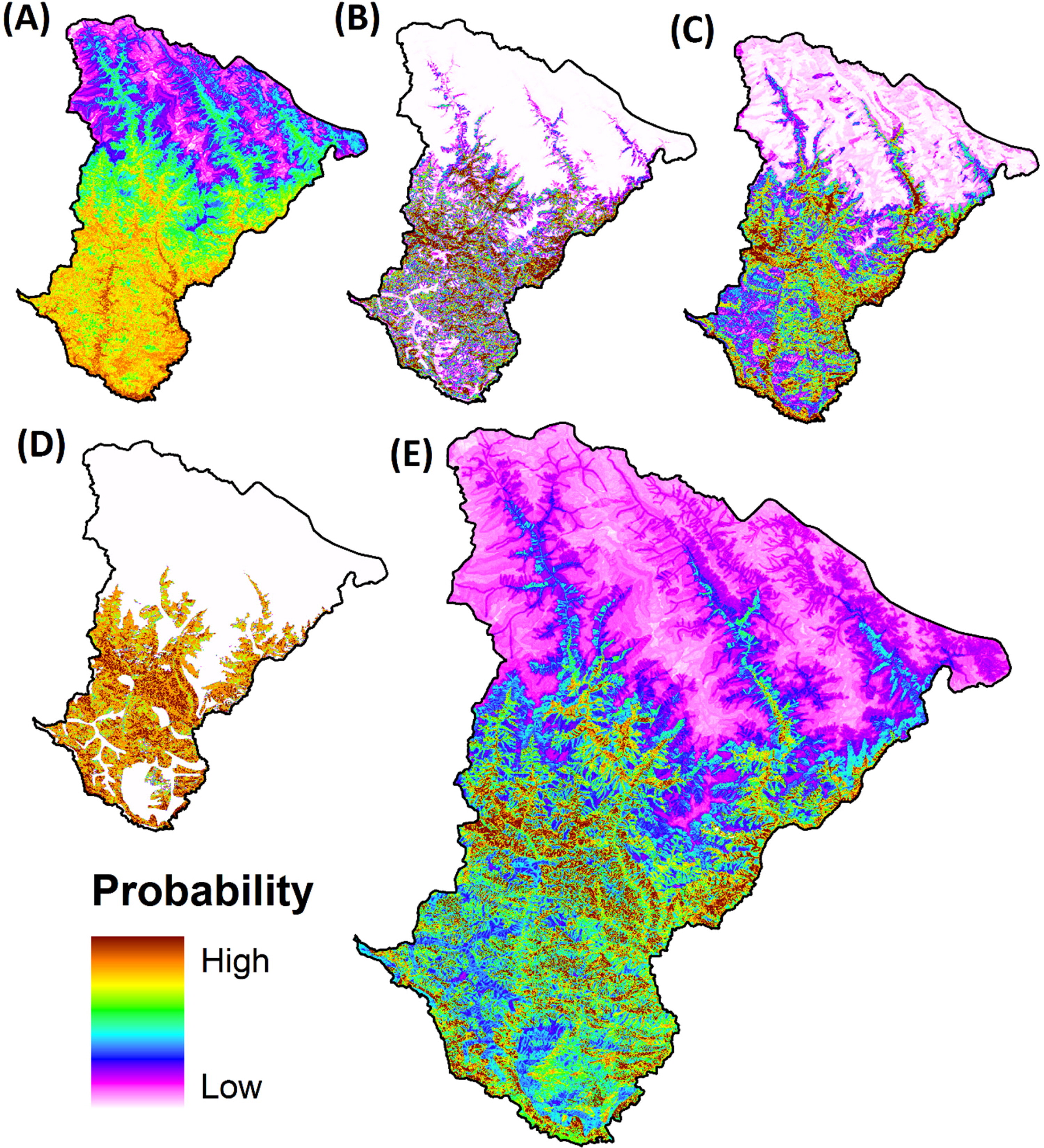
Recommended citation: Kaushik, S.*, Rafiq, M., Dharpure, J., Joshi, P. K., Singh, T., Howat, I., Moortgat, J., & Dietz, A.J. (2024). Glacial Lake outburst flood risk assessment and dam break modeling in Sikkim Himalaya. Remote Sensing Applications: Society and Environment.
Download Paper
Published in Remote Sensing of Environment, 2024
Recommended citation: Tang, Q., Zhang, G., Yao, T., Wieland, M., Liu, L., & Kaushik, S. (2024). Automatic extraction of glacial lakes from Landsat imagery using deep learning across the Third Pole. Remote Sensing of Environment.
Download Paper
Published in Science of Remote Sensing, 2025
Recommended citation: Dharpure, J.K., Howat, I.M., & Kaushik, S. (2024). Declining Groundwater Storage in the Indus Basin Revealed Using GRACE and GRACE-FO Data. Water Resources Research.
Download Paper
Published in Water Resources Research, 2025
Recommended citation: Dharpure, J. K., Howat, I. M., & Kaushik, S. (2025). Declining groundwater storage in the Indus basin revealed using GRACE and GRACE‐FO data. Water Resources Research, 61(2), e2024WR038279.
Download Paper
Published in Science of Remote Sensing, 2025
Recommended citation: Kaushik, S.*, Maurya, L., Tellman, E., Zhang, G., & Dharpure, J. K. (2025). Debris covered glacier mapping using newly annotated multisource remote sensing data and geo-foundational model, Science of Remote Sensing https://doi.org/10.1016/j.srs.2025.100319
Download Paper
Published in , 2025
Recommended citation: Kaushik, S., Tellman, B. (2025). DL4EO: A Unified Python Framework for Preparing Multi-Source Remote Sensing Data for any Segmentation Task. (Under-Review).
Download Paper
Published in , 2025
Recommended citation: Kaushik, S., Tellman, B., Howat, I. (2025). Beyond Clouds: Global glacial lake mapping combining Sentinel-1 and Sentinel-2 remote sensing data and a geo-foundational model. (Under-Review).
Download Paper
Published in IEEE Journal of Selected Topics in Applied Earth Observations and Remote Sensing, 2025
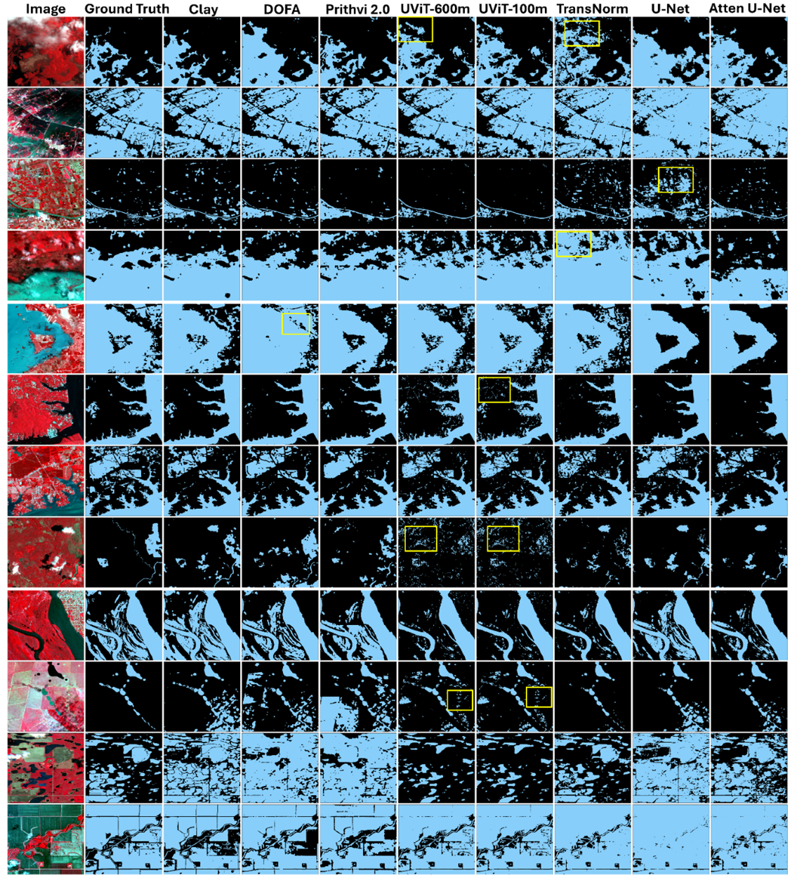
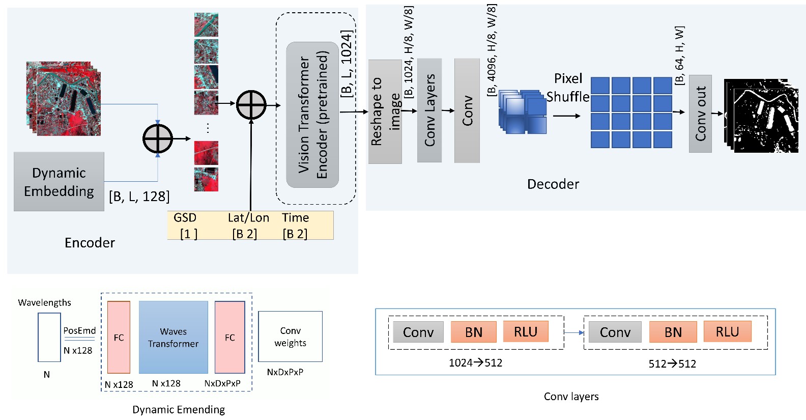
Geo-Foundational Models (GFMs) enable fast and reliable extraction of spatiotemporal information from satellite imagery, improving flood inundation mapping by leveraging location and time embeddings. Despite their potential, it remains unclear whether GFMs outperform traditional models like U-Net. A systematic comparison across sensors and data availability scenarios is still lacking, which is an essential step to guide end-users in model selection. To address this, we evaluate three GFMs, Prithvi 2.0, Clay V1.5, DOFA, and UViT (a Prithvi variant), against TransNorm, U-Net, and Attention U-Net using PlanetScope, Sentinel-1, and Sentinel-2. We observe competitive performance among all GFMs, with only 2-5% variation between the best and worst models across sensors. Clay outperforms others on PlanetScope (0.79 mIoU) and Sentinel-2 (0.70), while Prithvi leads on Sentinel-1 (0.57). In leave-one-region-out cross-validation across five regions, Clay shows slightly better performance across all sensors (mIoU: 0.72(0.04), 0.66(0.07), 0.51(0.08)) compared to Prithvi (0.70(0.05), 0.64(0.09), 0.49(0.13)) and DOFA (0.67(0.07), 0.64(0.04), 0.49(0.09)) for PlanetScope, Sentinel-2, and Sentinel-1, respectively. Across all 19 sites, leave-one-region-out cross-validation reveals a 4% improvement by Clay compared to U-Net. Visual inspection highlights Clay's superior ability to retain fine details. Few-shot experiments show Clay achieves 0.64 mIoU on PlanetScope with just five training images, outperforming Prithvi (0.24) and DOFA (0.35). In terms of computational time, Clay is a better choice due to its smaller model size (26M parameters), making it ~3x faster than Prithvi (650M) and 2x faster than DOFA (410M). Contrary to previous findings, our results suggest GFMs offer small to moderate improvements in flood mapping accuracy at lower computational cost and labeling effort compared to traditional U-Net.
Recommended citation: Kaushik, S., Maurya, L., Tellman, B., Zhang, Z., & Dharpure, J.K. (2025). Assessing the value of Geo-Foundational Models for Flood Inundation Mapping: Benchmarking models for Sentinel-1, Sentinel-2, and Planetscope for end-users. (Under-Review)
Download Paper
Published in WACV (GeoCV-Workshop), 2026
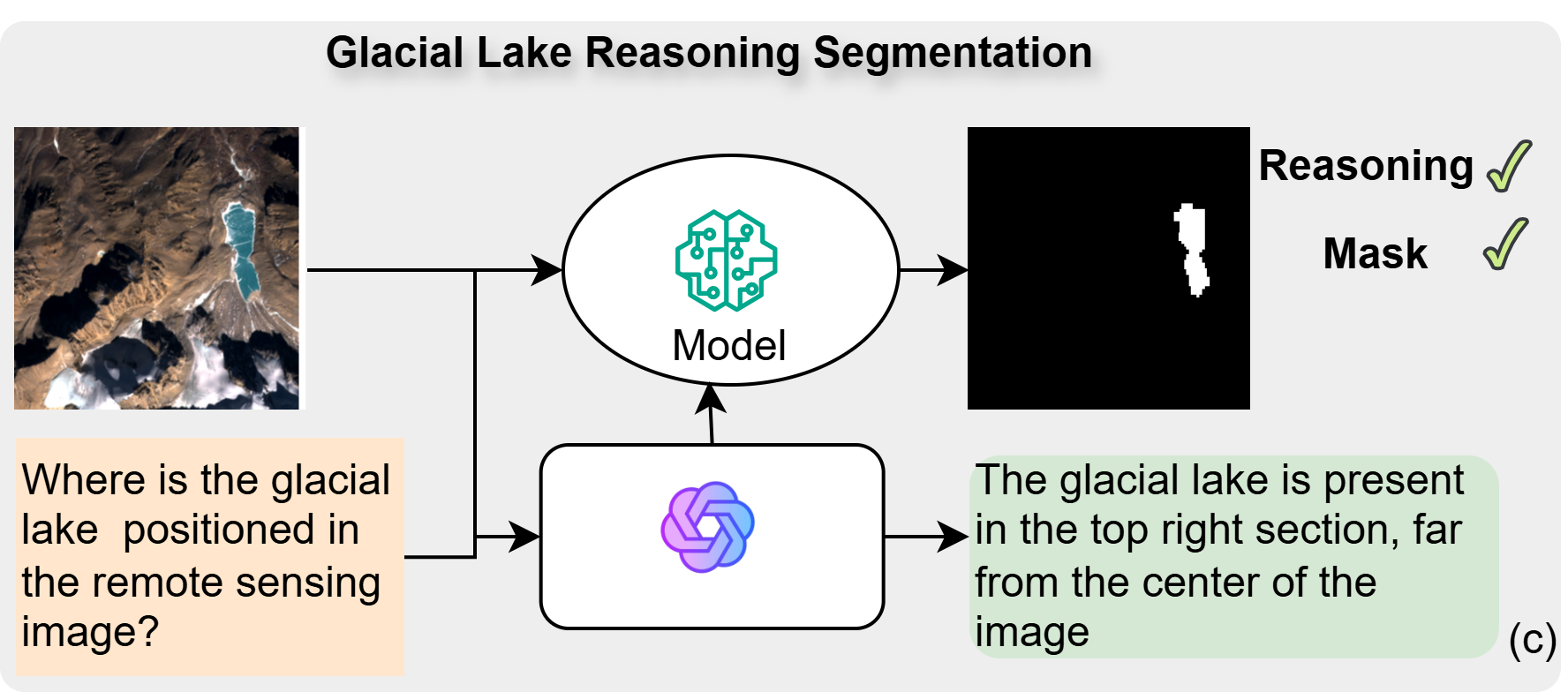
Recommended citation: Maurya Lalit, Kaushik Saurabh, Tellman Beth (2026). GLACIA: Instance-Aware Positional Reasoning for Glacial Lake Segmentation via Multimodal Large Language Model WACV (GeoCV-Workshop)
Download Paper
Published in WACV (CV4EO-Workshop), 2026
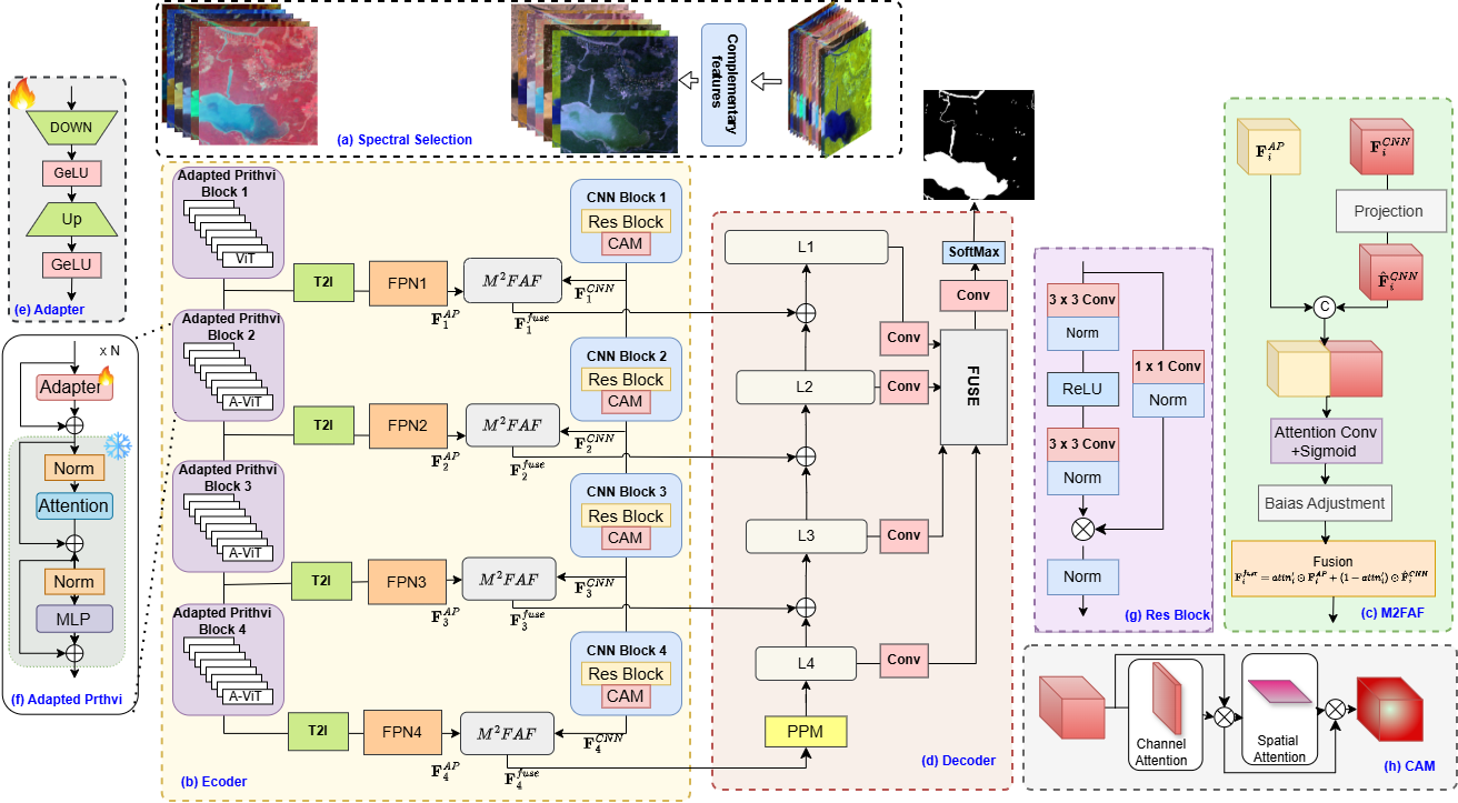
Recommended citation: Kaushik Saurabh, Maurya Lalit, Tellman Beth (2026). Prithvi-Complimentary Adaptive Fusion Encoder (CAFE): unlocking full-potential for flood inundation mapping (CV4EO-Workshop)
Download Paper
Published in Pre-Print, 2026
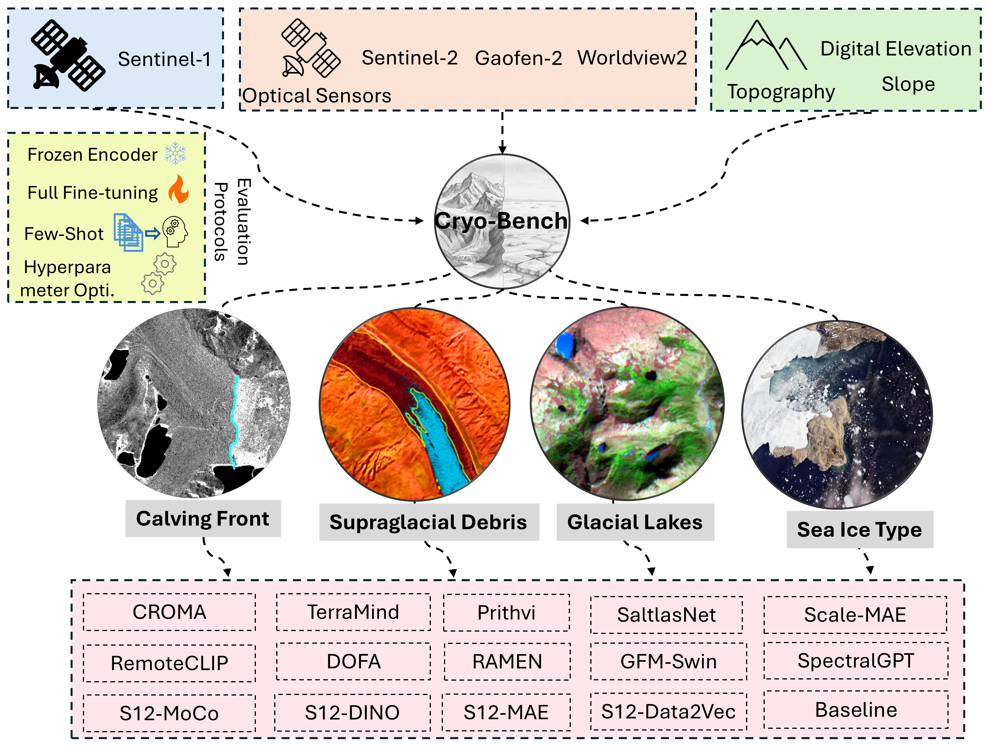
Recommended citation: Kaushik Saurabh, Maurya Lalit, Tellman Beth (2026). Cryo-Bench: Benchmarking Foundation Models for Cryosphere Applications
Download Paper
Published:
Delivered a talk on glacier feature mapping using multisource remote sensing data and deep learning at Byrd Polar and Climate Change Research Center Seminar Series 2023
Published:
In this talk, I presented findings from my first postdoctoral project carried out at The Ohio State University, which focused on geological hydrogen sources using AI-driven remote sensing.
, , 1900
Teaching is one of the most direct ways a scientist can impact the world and make it a better place. It provides an opportunity to engage with and shape the lives of students who are preparing to be the leaders and citizens of the next generation. I see teaching and mentoring as an opportunity to create transformative change, one person at a time. Having worked with numerous professors during my PhD and postdoctoral positions, I was fortunate to observe the best elements of their various teaching styles. I will incorporate these elements into my own teaching philosophy, which centers on three main objectives: (i) inspiring students’ curiosity to develop questions about environmental change, (ii) using empirical data—both qualitative and quantitative—to explore these questions, and (iii) fostering an understanding that conceptualizing trade-offs is often more valuable than finding the “right” answer. Underlying my teaching philosophy is a commitment to diversity and inclusion, encompassing gender, racial, class, sexual, ability, religious, and other identities. My interdisciplinary background allows me to teach a variety of courses. I can teach methods courses at both the undergraduate and graduate levels, including Geographical Information Systems (in ArcGIS, QGIS, or Python), Digital Image Processing, Fundamentals of Remote Sensing , Remote Sensing Applications, and Earth Observation using Machine Learning and satellite data.
Minimal-input pipeline to generate deep-learning datasets from Earth observation sources.